Water Resources Engineering Roadmap (2026): Managing Watersheds, Floods & Hydraulic Systems
Learn how to model and manage the water cycle. Master watershed hydrology, open channel hydraulics, 2D floodplain modeling in HEC-RAS, urban stormwater networks in EPA SWMM, and dam spillway design.

What's in this guide
The Short Answer: Water Resources Engineering in 2026
Water resources engineering controls, conserves, and distributes Earth's most vital resource. From protecting cities against 100-year flood disasters and designing resilient municipal storm sewers to building hydroelectric dams and managing critical groundwater aquifers, water engineers design the infrastructure that keeps communities safe and supplied.
In 2026, climate volatility has amplified extreme rainfall events and historic droughts. Water resources engineers must master 2D hydrodynamic river modeling (HEC-RAS), urban green infrastructure, and numerical groundwater simulation (MODFLOW).
Never mix up subcritical and supercritical flow regimes. A subcritical flow transition into supercritical creates drawdown curves, while the transition back produces an energetic, destructive hydraulic jump that requires a designed stilling basin.
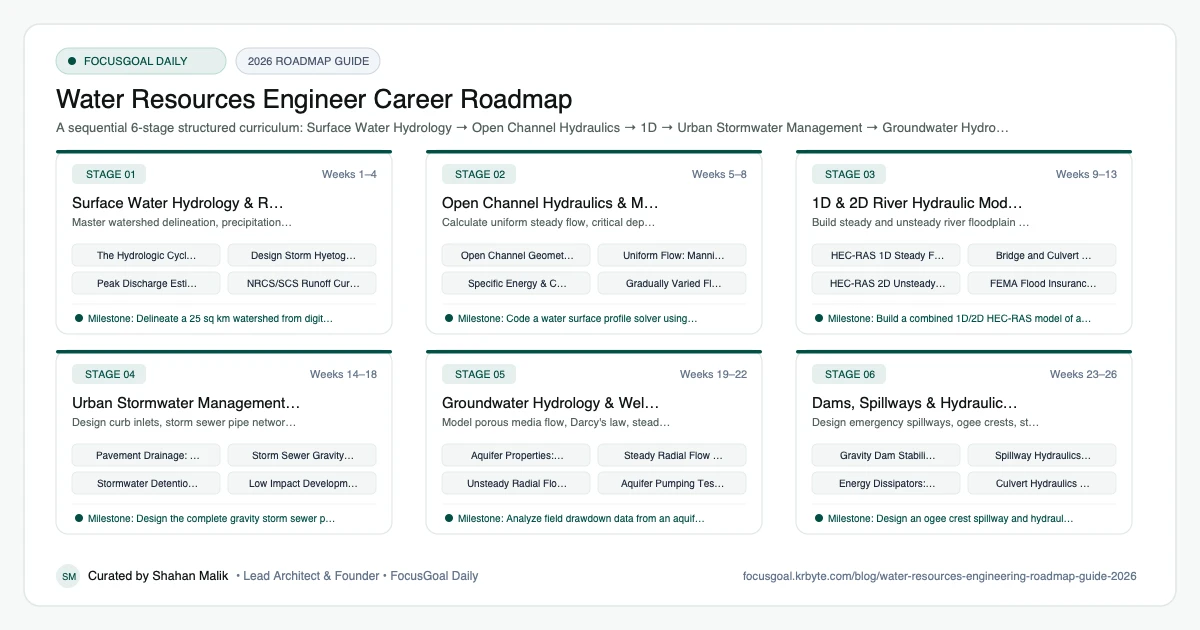
The 6 Production Stages
Follow these structured, sequential stages to systematically build production competence:
Surface Water Hydrology & Rainfall-Runoff
Master watershed delineation, precipitation frequency (NOAA Atlas 14), rational method peak flow, and hydrograph convolution.
Open Channel Hydraulics & Manning's Equation
Calculate uniform steady flow, critical depth, Froude number, water surface profiles (M1, M2, S1, S2), and hydraulic jumps.
1D & 2D River Hydraulic Modeling (HEC-RAS)
Build steady and unsteady river floodplain models using US Army Corps of Engineers HEC-RAS software.
Urban Stormwater Management & Drainage Design (EPA SWMM)
Design curb inlets, storm sewer pipe networks, retention/detention basins, and Low Impact Development (LID) green infrastructure.
Groundwater Hydrology & Well Hydraulics
Model porous media flow, Darcy's law, steady/unsteady pumping well hydraulics, and regional groundwater aquifers.
Dams, Spillways & Hydraulic Structures
Design emergency spillways, ogee crests, stilling basins, energy dissipators, and culverts.
Is Water Resources Engineering a Good Career in 2026?
Water resources engineering deals with water supply, flood management, drainage, dams, and irrigation. Climate variability, ageing infrastructure, and growing urban areas keep the need for water expertise visible in many regions.
Caveats: much work depends on public agencies and long-term infrastructure funding, and floods or droughts bring real consequences, so rigour matters. Pay and demand vary by country, so check official labour statistics and local agencies and consultancies. This is general education, not design advice.
- Good fit if you like hydrology, modelling, and public-benefit work.
- Employers include water utilities, consultancies, and government.
- Climate adaptation is a growing theme.
Software & Tools Water Resources Engineers Use
Water engineers rely on hydrologic and hydraulic modelling plus GIS and data analysis. Models are only as good as their input data and calibration, so learn to question results.
Understanding the underlying hydraulics, such as open channel flow, is more important than mastering any single interface.
- Hydrology and hydraulics: HEC-HMS, HEC-RAS, SWMM.
- Flood modelling: tools such as TUFLOW or MIKE, widely used by consultancies.
- Water networks: EPANET and WaterGEMS.
- GIS: QGIS and ArcGIS.
- Data: Python and R for rainfall and streamflow analysis.
Degrees, Licensing & How to Get Your First Water Resources Engineering Job
Most water resources engineers hold a civil or environmental engineering bachelor's degree, often adding a master's degree in hydrology or water resources. In the US, FE and PE exams apply, and licensure is important for public works. Other countries use chartered or registered routes. Requirements vary, so check your local licensing body.
Internships with water utilities, agencies, or consultancies are helpful. A portfolio project such as a small watershed model, a flood study with open data, or a drainage analysis, with assumptions and limitations clearly stated, demonstrates practical skill.
- Seek internships with water utilities or flood agencies.
- Learn HEC-HMS or HEC-RAS using free tutorials and data.
- Build a small watershed or drainage study.
- Check local registration requirements early.
Beginner Pitfalls vs Production Reality
Self-taught developers commonly waste months making avoidable structural mistakes. Here is how production engineers approach these challenges:
Master Water Resources Engineering with FocusGoal Daily
Water resources engineering integrates open channel hydraulics, watershed hydrology, and computational river modeling. FocusGoal Daily breaks your curriculum into structured daily study targets.
- Daily micro-tasks for Manning's calculations, hydrograph convolutions, and HEC-RAS parameters.
- Track study streaks offline during field stream gauging surveys or stormwater inspections.
- AI concept tutor for immediate explanations of Froude numbers, Theis well equations, and ogee spillway profiles.
Track this roadmap,
one topic at a time.
Download FocusGoal, pick this roadmap and finish your first daily topic in minutes.
Frequently Asked Questions
What software is essential for a water resources engineer?
HEC-RAS (river hydraulics and flood inundation) and HEC-HMS (watershed runoff modeling) from the US Army Corps of Engineers are the dominant global standards. EPA SWMM is mandatory for urban stormwater design, and GIS (ArcGIS Pro or QGIS) is essential for watershed analysis.
What is the difference between Hydrology and Hydraulics?
Hydrology is the study of how much water is generated by weather events (rainfall, snowmelt, watershed infiltration, and peak runoff flow rates). Hydraulics is the study of how that water physically moves through channels, pipes, weirs, and rivers.
What is a 100-year flood?
A 100-year flood (or 1% annual exceedance probability flood) is a flood magnitude that has a 1 in 100 (1%) statistical probability of occurring in any given year. It does NOT mean it happens only once every century.
What does a water resources engineer do?
A water resources engineer plans and designs systems for managing water, including supply networks, drainage, flood control, and dams. Work often involves hydrologic and hydraulic modelling, data analysis, and reporting.
Is water resources engineering hard?
It is challenging because it combines fluid mechanics, statistics, and modelling with uncertain real-world data. Practice with real datasets makes the concepts more concrete.
How long does it take to become a water resources engineer?
A bachelor's degree typically takes around four years in many countries, and many add a master's degree. Licensing timelines vary by country.
Water resources vs environmental engineering: what is the difference?
Water resources engineering focuses on the quantity and movement of water, while environmental engineering focuses on quality, treatment, and pollution. The two often work together.
Do I need a PE license as a water resources engineer?
For public works in many places it becomes important over time, though entry-level roles often do not need it. Rules vary by country, so check locally.
Start Your Water Resources Engineer Today
Follow structured daily goals, study 100% offline with local SQLite, and get on-demand AI guidance with FocusGoal Daily on Android.
Get FocusGoal Daily Free on Google Play