Transportation Engineering Roadmap (2026): Engineering Safe, Efficient Transit & Roadways
Learn how to plan and design modern transport networks. Master traffic flow dynamics, AASHTO geometric highway alignment, signalized intersection optimization, travel demand forecasting, and transit systems.

What's in this guide
The Short Answer: Transportation Engineering in 2026
Transportation systems are the circulatory system of modern society. Safe roadways, rapid transit lines, and optimized freight corridors reduce economic friction and save human lives. In 2026, transportation engineers face the dual challenge of modernizing aging road infrastructure while integrating connected vehicles, micro-mobility, and decarbonized transit networks.
The field requires mastering mathematical queuing and shockwave theory, 3D geometric civil design in Autodesk Civil 3D, and macroscopic travel demand forecasting in TransCAD or VISUM.
Adding lane capacity does not permanently resolve traffic congestion due to Induced Demand. Long-term mobility requires balanced multimodal networks (bus rapid transit, protected bike lanes, light rail) alongside optimized signal timing.
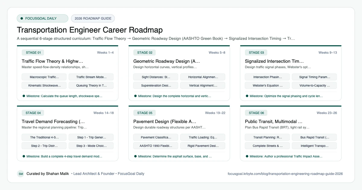
The 6 Production Stages
Follow these structured, sequential stages to systematically build production competence:
Traffic Flow Theory & Highway Capacity (HCM)
Master speed-flow-density relationships, shockwave propagation, Poisson queuing, and Highway Capacity Manual (HCM) Level of Service (LOS).
Geometric Roadway Design (AASHTO Green Book)
Design horizontal curves, vertical profiles, superelevation, and sight distances per AASHTO standards.
Signalized Intersection Timing & Optimization (Synchro)
Design traffic signal phases, Webster's optimal cycle length, yellow change intervals, and corridor signal progression.
Travel Demand Forecasting (Four-Step Model)
Master the regional planning pipeline: Trip Generation, Trip Distribution, Mode Choice, and Traffic Assignment.
Pavement Design (Flexible Asphalt & Rigid Concrete)
Design durable roadway structures per AASHTO empirical and Mechanistic-Empirical (MEPDG) design methods.
Public Transit, Multimodal Planning & ITS
Plan Bus Rapid Transit (BRT), light rail systems, complete streets with protected bike lanes, and Intelligent Transportation Systems.
Is Transportation Engineering a Good Career in 2026?
Transportation engineering plans and designs roads, rail, transit, and traffic systems. Demand is influenced by public infrastructure funding, urban growth, safety goals, and technology such as intelligent transport and electric mobility.
Caveats: much work depends on government budgets and long project timelines, and public consultation is part of the job. Pay and demand vary by country, so check official labour statistics and local agencies and consultancies.
- Good fit if you like systems, data, and visible public impact.
- Employers include transport agencies, consultancies, and cities.
- Safety and policy considerations are central.
Software & Standards Transportation Engineers Use
Transportation work uses design, simulation, and GIS tools, along with national design manuals. Always follow the manuals used in your region rather than general summaries.
Traffic data skills are increasingly important as sensors and connected data grow.
- Road design: AutoCAD Civil 3D, OpenRoads, and similar tools.
- Traffic simulation: PTV Vissim, Synchro, SUMO (open source), Aimsun.
- Planning and GIS: QGIS, ArcGIS, and travel demand modelling tools like TransCAD.
- Standards: for example the Highway Capacity Manual and the AASHTO Green Book in the US.
- Data: Python or R for traffic count and crash data analysis.
Degrees, Licensing & How to Get Your First Transportation Engineering Job
Most transportation engineers hold a bachelor's degree in civil engineering, with some pursuing a master's degree in transportation. In the US, the FE and PE exams apply, and PE licensure is important for signing public works designs. Other countries use chartered or registered systems. Requirements vary, so check your local licensing body.
Internships with transport agencies, consultancies, or city councils are valuable. Strong portfolio items include a corridor or intersection study using real traffic count data, with clear assumptions and recommendations.
- Seek internships with agencies or city traffic departments.
- Learn one traffic simulation tool and Civil 3D.
- Complete a traffic study with open data.
- Check local registration requirements early.
Beginner Pitfalls vs Production Reality
Self-taught developers commonly waste months making avoidable structural mistakes. Here is how production engineers approach these challenges:
Master Transportation Engineering with FocusGoal Daily
Transportation engineering involves memorizing rigorous AASHTO design criteria, traffic stream equations, and signal timing parameters. FocusGoal Daily turns this curriculum into disciplined daily study goals.
- Daily micro-tasks for horizontal/vertical curve math, Webster cycle lengths, and ESAL calculations.
- Track study streaks offline while conducting field traffic counts or road site surveys.
- Instant AI explanations for Greenshields models, Wardrop's equilibrium, and AASHTO K-value formulas.
Track this roadmap,
one topic at a time.
Download FocusGoal, pick this roadmap and finish your first daily topic in minutes.
Frequently Asked Questions
What software is most common in transportation engineering firms?
Synchro and SimTraffic are dominant for traffic signal timing and small corridor simulation. Autodesk Civil 3D is standard for geometric roadway design. Vissim is used for micro-simulation, and TransCAD/Cube is used for regional 4-step demand planning.
What is the difference between Traffic Engineering and Transportation Planning?
Traffic engineering focuses on physical operations and immediate safety: signal timing, geometric highway design, signage, and striping. Transportation planning focuses on long-range 20-30 year regional policy: forecasting travel demand, transit corridors, and funding allocation.
What is Level of Service (LOS)?
Level of Service is a qualitative measure defined by the Highway Capacity Manual describing traffic operational conditions (LOS A = free-flow to LOS F = severe breakdown and breakdown queues).
What does a transportation engineer do?
A transportation engineer plans, designs, and operates systems for moving people and goods, including roads, intersections, transit, and traffic signals. Work includes traffic studies, safety analysis, geometric design, and public consultation.
Is transportation engineering hard?
It is moderately demanding, combining maths, data analysis, and design standards. The challenge often lies in balancing safety, cost, and community needs.
How long does it take to become a transportation engineer?
A bachelor's degree typically takes around four years in many countries, and some add a master's degree. Licensing timelines vary by country.
Transportation vs civil engineering: what is the difference?
Transportation engineering is a specialisation within civil engineering focused on movement systems. Civil engineering also covers structures, geotechnical, and water.
Do I need a PE license to be a transportation engineer?
For public works designs in many places, yes, eventually. Entry-level roles often do not need it, and rules vary by country, so check locally.
Start Your Transportation Engineer Today
Follow structured daily goals, study 100% offline with local SQLite, and get on-demand AI guidance with FocusGoal Daily on Android.
Get FocusGoal Daily Free on Google Play